Sunday, February 21, 2010

2010 Leadville Winter Series #2


My camera was set on the wrong setting, but it looks like I was trying to do something arty with this shot from the balcony. You decide, screw-up or art.

The race thumped me good and hard. I did not win. I did not vomit. Somewhere between those two.

Always fun to be part of these races.

Saturday, February 13, 2010

Tour de Palm Spring 2010

I've done this thing a bunch of times. It used to be kind of a "normal" century ride. Now it's 10,000 rolling bikes. It's an amazing number of riders.


After all the riding I did in the 10 days leading up to this year's tour, I was quite mortal. I finished in a little under 7 hours.

Friday, February 12, 2010

Art Smith Trail

I wasn't necessarily planning to ride my mountain bike two days during my visit to my folks. I was going to probably take the day to rest up a bit, hang with the 'rents, maybe buff up my road bike...

But yesterday's ride whetted my appetite. And furthermore, when I looked at the map I could see where Hopalong Cassidy intersects the Art Smith Trail (the plan for Friday). I had trouble following Hopalong that far--it ran into a new housing development. There was a sign that said the trail continued, but it looked like it could have gone any of a number of ways. And I was ready to turn around anyway. But I wanted to explore to see what things look like from Art Smith.

The trailhead was easy to find, I got rolling. More accurately, I should say I got pushing. The beginning of this ride had me thinking I had made an unfortunate choice. Some was rideable, but much elevation was being gained in a compressed area.

Then, just past where I met the intersection with Hopalong Cassidy (yes!) things started to level off. And then it became kind of spectacular:


Nice ride. Really nice ride. For lots of it, there was no way to tell that a big urban area was just right nearby.

Looping: a guy could start down at the bottom of Art Smith, ride it to where it hits highway 111, ride along the highway for what looks like a mile or less, then climb back up Hopalong to the intersection with Art, back down to the starting line.

Nice find. Hope I get a chance to do this again soon.

Thursday, February 11, 2010

Hopalong Cassidy Trail

My folks are snowbirds who spend their winters in the Coachella Valley Sprawl-o-plex. It's pretty much a classic southern California suburban landscape, but it's surrounded by lots of interesting natural landscapes. The San Jacinto Mountains loom above the valley to the west. Joshua Tree National Park is pretty close to the north.

I had heard that there were some good mountain biking trails, but after many years of visiting my parents there, I had never found one that I thought was worth going to back to see again.

My dad gave me a guidebook for cycling routes in the Palm Springs area last year. I cracked the book open Thursday morning, picked a promising-looking trail, and then used mapquest to figure out how to get to the trailhead.

Guess what? It was pretty damned good:


Lots of people up there, all of them on foot. I saw exactly zero other mountain bikers. But that's OK, there isn't anything wrong with walking. People seemed pretty OK with the idea that I was riding, though some were kind of incredulous.

The best news about this trail, I now know how to use it to make a nice fat loop with the ride that I did Friday.

Tuesday, February 9, 2010

Soft landing at Sweetwater

The morning after the Ripsey ride I woke up feeling like I'd been beaten with a garden hose full of sand. Gary and I had ridden four days in a row, and all four riding days were either long or anaerobic or both--at least for me and my mid-winter fitness. Then on the fifth day we did Ripsey.

At the end of the Ripsey day I had crawled into my sleeping bag shivering and with a belly bulging with food. It took me a while to fall asleep with my heart beating fast. I woke up in the middle of the night with a dry mouth and with a full bladder.

In the morning I felt worked. Legs stiff and tired, eyes puffy, brain thick and foggy. We loaded up and rolled back down the Freeman Road, crossed back over the San Pedro River and hit highway 77 back toward Oracle.

On the way back south, I called AdventureLee because we had been talking about making another attempt to ride together Tuesday. Gary and I had already agreed that neither of us felt strong enough to do anything remotely epic, but we were into doing something light, and wanted Lee to be there if he could. He told me that he really had some important work that he could do, and the 2 hour round trip just for a short ride didn't seem like a great bargain. He told us to call and let him know what we decided to do, but that he'd probably stay home and work. Then he told me about a good restaurant in Oracle. I had eaten some cold cereal before we left, but a real hot breakfast sounded heavenly.


After breakfast we went to my friend Jake's house in Oro Valley. Jake and his wife Tracy live in Salida during the months when our weather is good, and Tucson when their weather is good. Doesn't that sound like a good idea?

I had brought Jake's singlespeed from Salida, and it had ridden on the rack on the back of the tPOD through two significant wet weather systems. I delivered the bike, and Gary and I accepted an invitation to stay for the night. Then we got in touch with Scott Morris and worked out a plan to go ride a fun place, Sweetwater, which is a Pima County resource designed by Mark Flint (yep, there's that name again).

Gary and I rode over there with Jake, met Scott, and had a blast. It was just about exactly as much as my legs had energy for. And it was really fun. The weather was sweet, but just like Saturday night, that didn't mean that there wasn't crappy weather on the way.

The Wednesday rain system made itself known at dawn. It wasn't raining exactly, but the sky was gray and the smell of rain was there. Gary talked to Scott, and he suggested that we could ride, Starr Pass being mentioned as a good idea. But I was feeling even more worked over than Tuesday morning. As most of us endurance ride junkies know, the morning after the morning after is when the real extent of one's tiredness and pain is felt. Riding, especially a ride that might be interrupted by a big 'ol rain storm, just didn't sound good to me.

My next destination was southern California to visit my parents and do a century ride on Saturday. I had promised them that I would be there by nightfall (5 hour drive from Tucson). Gary was going to head home as soon as we wrapped up our riding.

So that was that. Jake fed us one tasty waffle after another, then Gary headed out, east on I-10. I yakked with Jake for a few hours, then headed out, west on I-10. 25 miles out of Tucson I rode into torrential rain. It was the 3rd big, wet weather system I'd been subjected to in the last 7 days.

I made the folks place by dinnertime. Road Trip Part II began.

Monday, February 8, 2010

Big Adventure Out North

As we at dinner at the picnic table in our campsite in Catalina State Park Sunday, Gary and I discussed strategy. Weather was our nemesis. We clearly had a blue chip weather day coming for Monday, and Tuesday also looked promising. Wednesday's weather was a question mark.

The ride that we had been planning to do with AdventureLee, the Ripsey Section of the Arizona Trail, was the must-do ride that neither of us wanted to miss on this visit to southern AZ. We were hoping to ride Tuesday with Lee, and ideally we would have gone together up to Kelvin, AZ that day. But Lee told me that he really couldn't afford the time to go all the way up there again.

We decided that we really should go up there and ride it. We should get up in the morning, load up our stuff, and then drive up there. We would ride the ride then camp where we finish. We figured that we would drive up to Kelvin, where we were going to meet Lee, and do the loop he was going to lead us around.

Lee was going to send us the GPX for that loop. And I also had a GPS track from the AES site for the Antelope Peak Challenge, where a new option for the 2010 ride went north from Antelope Peak to the Ripsey Section, then looped back using the Florence-Kelvin Highway, a graded gravel road. Chad called me that night and I told him what we had planned. When I asked him how we should do the ride, he said we should just go out to Antelope Peak on the Freeman Road and do the ride as a lollipop just as the APC had done in January. So in the morning, that was the idea I pitched to Gary.

We stopped at the Catalina, AZ library on our way north, got some GPX info, looked at Mapquest to see how we wanted to get up there, and then got going. Chad had recommended that we just take the Willow Springs Road north to the Freeman Road, but we saw that following highway 77 north to a place called Dudleyville could get up pretty close on pavement, then we could pick up the Freeman Road and head west to Antelope Peak. We stopped in Oracle, AZ to drop off Valentine's Day cards for our sweeties at the postoffice.

It was a pretty short drive to Dudleyville, and when we got close we started slowing down for each possible left turn to look for a sign saying "Freeman Road". Lots of the intersections were not marked, and none were what we wanted, so after we started leaving Dudleyville behind, we went back to the only gas station/convenience store there to ask directions.

Inside there was only one employee, a woman probably in her mid-3o's. I asked her if she could tell me how to get to the Freeman Road. Her eyebrows went up and her expression became strained. She blew out a deep breath and said something like, "Oh boy, I don't know exactly what to tell you. This is going to be kinda hard."

"You don't know where it is?" I asked.

"Well, it's hard to find, and they're trying to close it. It's them conservationists. They want to close it down to us. Guess there's some kind of bird up there."

"But there are people up there all the time, ranchers and gas line workers, aren't there?" I asked.

"Well yeah, there's people that live up there, and they probably don't want you up there either. Be careful if you go, you might find stuff in the road."

I pictured things like sharpened rebar. "So there might be pieces of metal or something?" I asked.

"Or road closed signs." She said knowingly.

"Well, I think we'll take our chances if you'll tell us how to find it."

She blew out another breath and then gave us directions, turn at the old crusher, cross the San Pedro River (about a foot deep, no bridge) then follow the railroad tracks...

We headed out, saw a road crew working across the river from our crossing, and Gary got some more complete directions from them. And we were on our way.

The conversation with the woman at the convenience store was a bit of amusement, but in retrospect I regret not following Chad's advice. I think it would have been a more direct way to just get there without all the farting around.

We drove south on the side road that goes to the foot of Antelope Peak and found a place to car camp. Then we set about starting on our journey. We had burned a fair amount of the day. It was getting close to noon. Chad had said the lollipop was a 7 hour trip. And those are 7 Chad hours. Gary is faster than I am, but he would probably be forced by good manners to take as long as I would take to finish. And that would most likely be more than 7 hours, assuming no mechanicals or vomiting from too much exertion.

Basically, it was pretty much a sure thing that we would finish in darkness. We attached lights. I looked for my Oakley M-Frame clear lenses. I have prescription lenses. As I like to tell people "I don't really need these glasses. Unless I want to be able to see." I looked and looked. I started looking in places where I had already looked. After half a week of living out of the truck, things were a little cluttered. I burned too much time looking for the damn things, and finally took a spare set of regular inside glasses I keep in the truck that stay on my face fairly well. Food, warm clothes, plenty of water. I had some trouble getting my hydration pack to zip closed.

At something like 12:30 we rolled. Gary had his GPS bar mounted (my bar mount sucks a$$ so my GPS was in a backpack side pocket). Gary was new to GPS navigation, so this was a pretty good exercise for him.

I've ridden the Boulders section of the AZT several times. It's fun and flowy, and it rolls out into desert that is more and more remote. The Freeman Road travels through some pretty remote country, but once you head north from there you're really getting out into it.

Very soon, the feeling of being rushed to get going passed and we were just out there. Yep, it was going to get dark before we finished. We had enough food, clothing, etc. Might as well stop and take some pictures.

My camera, did I pack it in the stuffed "no room for anything more" backpack?? I looked. Nope. All the pictures would have to come from Gary's camera.

We progressed through the Boulders section, past the namesake boulders, then beyond any of this AZT section I had ever seen. New frontier. There were a couple sections of powerline service road, with the standard man-eater erosion ruts and v-bottom crossings. Then there were some sections of singletrack that were completely faint, mixed in with cowpaths. I told Gary, in some of those places I think trailbuilding was really just a process of gathering rocks to stack into cairns. The recent rainfall had obliterated most of any tracks other than a horseback rider. Gary and I made note of this, and both wanted to be through this bit before it got dark enough to make route-finding tough. Turns out that we did do that, make it past this area while there was still ambient light, but just barely.

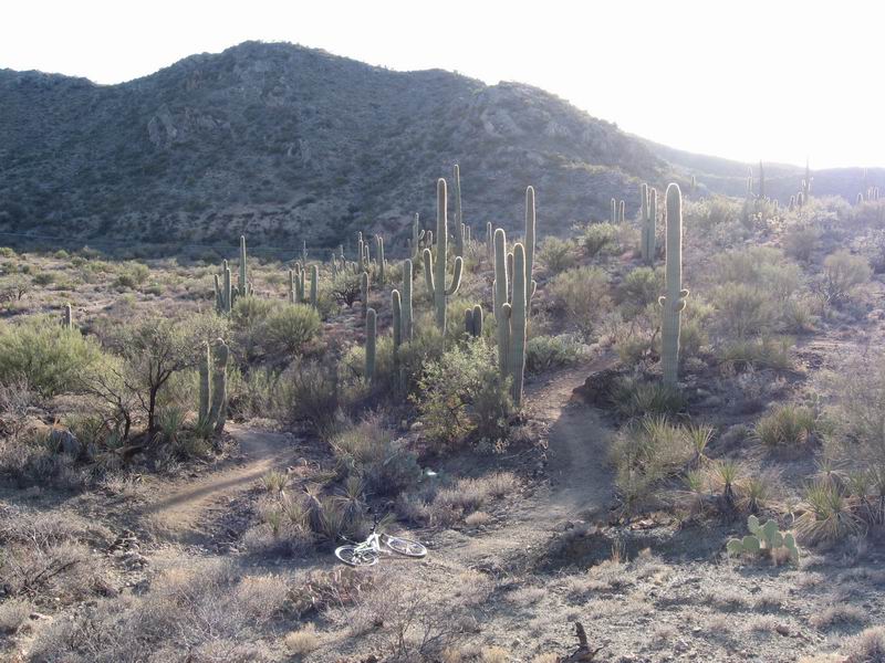
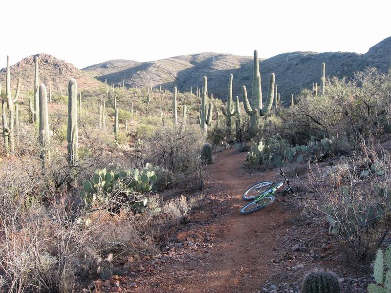
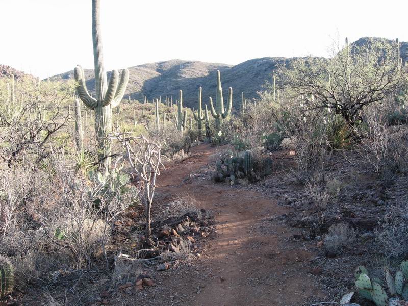
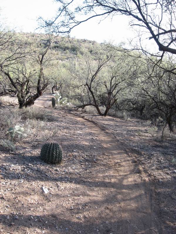
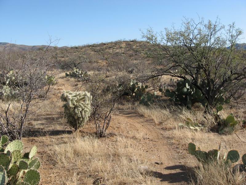
At some point we passed a sign that said "Ripsey Hill Section of the Arizona Trail". As we continued, things got pretty damned cool. There was so much. The single word that I think both of us agreed summed it up: spectacular. I'll let the pictures tell some of this:


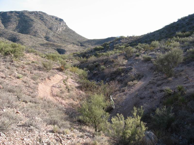
We dropped off the high ridge down a series of tight switchbacks. It was really an elevator ride down. Then the trail dumped us out onto a jeep road. We gave up another couple hundred feet of elevation and then arrived at the intersection with the Florence-Kelvin Highway. If there had been more time, it might have been fun to go check out the Gila River just a little way down the road to the north. But we were burning daylight, and it was time to make the return.

From here, the GPX file became more than valuable. We used Gary's GPS to find the right turn off the dirt road onto a doubletrack, and we used it actually to select the correct doubletrack of the two that branched off from that turn. There were countless forks in the doubletrack after that, and we were not on the AZT so there was no expectation of signage. When we did rejoin the AZT, we encountered forks that were not signed as well. Some we remembered because by then we were tracing our track back. But some were a mystery. A map would not have been helpful. There was simply too much detail, and it would have taken too much map-reading time.

The sun went below the horizon about the time that we got back onto the AZT and our outbound route. The sky was beautiful, but we were both anxious to get past the hard-to-follow sections while we were still in twilight.

By the time full darkness fell, we were pretty much back to singletrack AZT. Now it was just time to plug away at the miles to get back to camp where we could eat and go to sleep.

The Boulders section just feels really flowy on your way to the north from the Freeman Road. And that's because it's just slightly downhill all the way. On the way back to the Freeman Road, it's slightly uphill all the way. That's just how this stuff works.

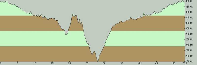
Our starting point was actually the highest point on the whole ride, as you can see from the elevation profile:


It seemed like it took forever. My legs were really getting tired. I love night riding, but it's a lot more fun when you aren't feeling trashed.

But we got done. And we ate food, and with almost no conversation or sitting around, we went off to sleep.

Stats
53.25 miles
A little over 7 hours moving time
A little over 8.5 hours elapsed time
Total Climbing: 6643 ft (is that all?!?)

Sunday, February 7, 2010

Sunday Brings a Change

Saturday afternoon and evening treated us with classic southern Arizona fair winter weather. The air was calm and warm but not hot. There were some high clouds, but nothing that looked threatening in the least. I wore shorts and sandals even as darkness slowly settled on the desert.

We had been watching an NWS forecast for rain showers Sunday since before we left home. But we simply could not believe that it would happen. After dinner I spoke to AdventureLee and confirmed plans to meet him along the Florence-Kelvin Highway near the Gila River around 8 AM in the morning. We all agreed that rain seemed unlikely. Gary and I set alarms and went to sleep assuming that we would get up, break camp, and go have an adventure in the remote desert way north of Tucson.

Between 4 and 5 AM rain suddenly started hammering on the roof of the tPOD. I stayed in bed until my alarm went off but didn't really sleep, it was too loud. After my alarm went off I went looking for Gary. He was up, making coffee on the tailgate of his little Toyota pickup, bustling about in a rain jacket.

I called Lee who was way out north, 30 miles down a dirt road. We agreed quickly that our large planned ride was not a good idea for that Sunday. I invited Gary into the camper and we sat drinking coffee for a while, then decided to head out to find a coffee shop, hopefully with WiFi, to get some breakfast and information.

We broke camp and headed east into Tucson. It was early, and we flailed around for a while trying to find a place to go. Finally we found a restaurant in Oro Valley, north and west of Tucson proper. Turned out it did not have WiFi (what?!?), so we ordered a hot breakfast and then made our way to a library. We did not expect to find it open, but hoped it wouldn't be long. Libraries are a great place for a traveler to hang out when there's down time. Turned out that the only Pima County libraries that would open on Sunday opened at 1 PM. We learned this by accessing the network from the parking lot. We also reviewed the most up-to-date forecast, which said that Monday should be fine but that Wednesday could be another rain day. Damn!

After a while, we started wandering around in the very light rain and saw that west of us there was a break in the clouds. Blue sky. And as time went by, it seemed to be getting closer. Maybe we would get to ride. I was thinking about where to camp when the ground is really wet. Out on State Trust Land somewhere in the remote desert seemed a bit risky, since we could have trouble with roads and could have trouble finding a spot that wasn't a mud bog. Catalina State Park seemed like a really prudent choice since you don't need to leave pavement to get to a camp site, the 50 Year Trail heads right out of the park, and there are amenities like showers. A shower sounded really good. And Catalina State Park is just a really nice place, and not expensive either.

As we discussed this, the rain stopped altogether. So we decided not to waste any time and just get on with it.

We got in there, got a nice site, and started kitting up for a ride. We looked at the map they gave us and saw the option to take the Sutherland Trail back to the park rather than a simple out-and-back on 50 Year. I had seen the option before, but never had ridden that trail. So we decided to take that option on our return if it worked out.

At the start, I looked off to the west and saw a dark cloud headed our way. The rain started again just as soon as we started climbing out of the park on 50 Year. It's pretty sandy, so the trail condition wasn't a problem for the most part, but my wool jersey was quickly getting soaked. I grumbled, than stopped to put on my jacket. When I stopped, I noticed that the landscape had been made dramatically beautiful by the rain and mixed light of a localized rain squall.

I did not take many pictures on the Arizona Trail near Colossal Cave because I have photographed it so many times before. Some of the photos I included were actually archive photos from years past. And I didn't take many in the Tucson Mountains because I was busy. But I took quite a few on this ride. Check 'em:


The Sutherland Trail option turned out to be quite a bit more interesting than I had expected. It started with a pretty long, steep climb on bowling balls. Reminded me of home ;)

When we encountered the singletrack, we found a very technical, very interesting trail. The huge sweeping views were amazing.

Even though I've ridden 50 Year quite a few times in the past, and I wanted to see new and interesting trails on this visit to AZ, I found Sunday's ride to be fresh, challenging, and quite interesting. And as Gary pointed out, it was a bonus. We woke up in the morning assuming that we would have to wait out the rain all day, but we wound up getting a really good ride in.

And then we got showers.

Saturday, February 6, 2010

Tucson Mountain Park and Brown Mountain

After we thoroughly examined the Arizona Trail both north and south of Colossal Cave Park east of Tucson, we headed west. We had a map and we had a couple trails that we wanted to ride: Brown Mountain and Golden Gate.

We got a campsite at Gilbert Ray Campground just west of Gates Pass. Then we ate some lunch and went about finding Brown Mountain.

It wasn't far, but right away we found signage to be spotty. After just one or two wrong turns, we found what certainly seemed to be the Brown Mountain Trail. We traversed along the base of a rocky ridge, encountering lots of technical features and tight switchbacks. Then we reached the end of the ridge, and the trail went up and up. It was the warmest day of our trip so far, and I broke a true and enthusiastic sweat.

It was up and down, and it was technical.

Truly beautiful trail.

Which reminded me of my pretty little Kathy, who couldn't come with me on this trip because of the limits of her vacation time.

Here is Gary on a rare smooth bit.

The conclusion of the Brown Mountain loop took us pretty much back to Gilbert Ray. So from there we headed south, seeking the Golden Gate Trail. There are a combination of singletrack and doubletrack links that we used to get south. We took the Campground Trail to the Sego Trail to the Gates Pass Trail to the Mariposa Trail to the Avery Bryce Trail to the Kerr Jar Trail to the Golden Gate Trail. Or at least that's what we assumed, because non of them had signs. We just went by what it looked like our map was showing us. And for the most part it made sense.

Then we climbed up what we assume was Golden Gate. And it was really nice. It was a fairly gradual climb with the occasional technical feature--a climbing ledge or narrow rock gap. Then it seemed to just go back out to the Gates Pass Road. There was an option that went right, in the direction we assumed we needed to go, but it looked like a faint hiking trail.

We opted to bag it and try to find the Orcut Trail. By our map it looked like this could be accomplished either by riding right down the Gates Pass Road or by taking the Ironwood Trail to the Chaparral Trail. There was a sign for Ironwood, and we took the trail behind the sign. But then it got confusing. There were branches and braids and intersections appearing constantly. Some were marked with cairns. We tried to stick with what looked like the "main trail" but it was hard to tell most of the time.

Eventually we just looked for trails that seemed to be going out to the road. We took a couple that seemed to go the right way, then turned to go either back where we came from or in the other direction. I think it's just too easy to make a trail in that environment. You really don't need any tools, you just start riding something.

But of course, it all worked out. We got out to the road, we found the start of the Orcut Trail, and we were on our way. Orcut had some moments. There were parts of it that were doubletrack, but even some of that was technical enough to be fun.

Verdict on Tucson Mountain Park:
  1. It's incredibly beautiful.
  2. You need a guide or something better than the crappy map we printed out at the library from the internet.
  3. I want to see the portion to the southeast, Starr Pass and all that.
But tomorrow, elsewhere. We had plans to meet up with AdventureLee way up north to see a remote and rare section of the AZT. Alarms were set for O Dark Thirty.

Friday, February 5, 2010

AZT south toward the Santa Ritas

In the morning I suggested that we ride the AZT south out of Colossal Cave past I-10 and as far as we could. Lots of good singletrack has been built out that way in the last couple years, and Gary is an AZT enthusiast, so he was all for it.

I'll just let pictures talk:


Here are some that I took many years ago from inside Colossal Cave:


It was an excellent Day 2. But I was ready to see some Tucson riding I'd never seen before. So that was next on the agenda. Tucson Mountain Park.

Thursday, February 4, 2010

Pilgrimage Begins

Over the years I have taken many mid-winter road trips to the south and the west to satisfy my cravings: Singletrack, cactus, mexican food, sunsets and warmth! Often, actually very often, weather puts up obstacles to my pilgrimage.

My schedule was suitably clear of commitments to allow me to leave Tuesday, February 2. But Mother Nature, as interpreted by the National Weather Service, told me not to bother showing up until Thursday since she was planning to pour water all over Pima County on Wednesday.

So I left Wednesday morning. The weather that was working overtime in Tucson smacked me in the face right on the south side of Española, NM. I was in heavy snow on very slick roads as I climbed past the opera toward Santa Fe. The wintery weather was hardcore until I got about halfway between Santa Fe and Albuquerque. Past there it was rain. Just rain. Buckets of rain.

I had planned to pull off somewhere near Deming, NM to pop up the tPOD and sleep. Everyplace I looked off the road, I saw mud. I didn't want to wake up stuck, and wondered if the sound of hard rain drumming on the camper would be very restful. So I got dinner at Irma's in Deming and then I was back onto I-10 to drive into the evening with my wipers running the whole time.

I finally drove more or less out of the rain as I neared Tucson. I went up onto Pistol Hill and found a fairly quiet place to crash in the tPOD.

I woke up in a moist desert under clear skies on Thursday morning. My travelling companion Gary from Del Norte, CO, was due to arrive in Tucson a bit after lunchtime. So I decided to suit up and take a ride. I went on into Colossal Cave Park to get a camp spot. Then I suited up and headed north out of La Sevilla to Rincon Creek. That section is about 8 miles long, and it's just fun. Fast and swoopy, with lots of stickery cactus and scrubby trees to keep you honest.


Smooth and fast singletrack


One of many beautiful Mark Flint turns

After I rode it, I ate some lunch, met Gary, and rode it again with him.

Ah yes, the journey has begun to bear fruit.