I've been drawing permits to hunt deer and elk in Colorado for the last decade, on and off. I've put in serious efforts, casual efforts, and some years I've blown off hunting the permit altogether. My feeling about buying hunting and fishing licenses is that it's not a bad place to contribute money. It's not for nothing, even if I don't shoot or catch anything. And hunting is an excuse to spend a bunch of time outside, looking and listening intently.
Point is, for my ten years as a big game hunter in Colorado I have never managed to be any threat to the well-being of any game. I've tried to get smarter about it; reading, talking to people who hunt, thinking about what I've done that hasn't worked. One of the things I have known is that I move around too much. Better off getting somewhere and staying put, but I get antsy, or cold when I'm sitting. A better strategy is to be quiet, stay in cover. Look and listen. Use your binoculars. Be patient.
This year I decided to take it a little more seriously. I have a camper again, so I did a bunch of exploring around my game unit, which was actually a handful of game units, in the Arkansas Hills north of Salida, and decided where to locate hunt camp. I intended to go up and stay up for at least the first three days of the season. Wednesday (10-19-2016) I dragged my camper up a heinously steep, rough jeep road. Then came back Friday outfitted to stay and hunt. Saturday morning long before light I was putting gear together then driving my truck half a mile down another jeep road.
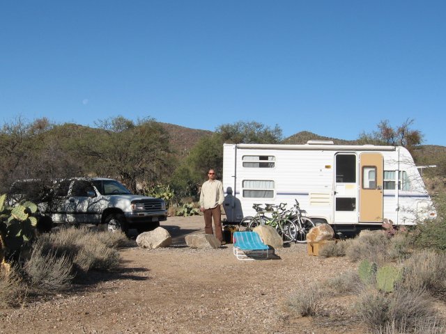
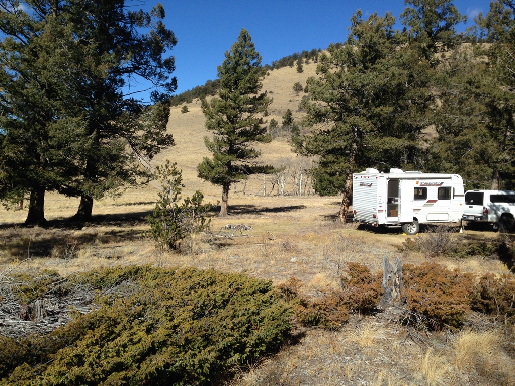 Hunt Camp
I'm going to tell the story of the hunt, but first will reveal a spoiler: I did shoot a deer. In the story that follows, there are some very specific descriptions of things I saw and did that might be hard for some people to read. Killing and field dressing a large animal is an intense and humbling experience. And often quite gory. Much of this is described. Be warned.
Morning hunts are about getting to where you want to be sitting an hour before it's legal to shoot. Bothering to wake up in the hills right where you want to start hunting on opening day is worth the trouble, or at least it should be. The one nearly-shot I had at a cow elk years ago was on an early morning opening day. After that, never saw another animal the whole season. So Saturday morning 90 minutes before sunrise I was heading down into a draw that's more or less familiar to me from scouting.
I had made a GPS line to follow, but it was hard going. Darkness, backpack, rifle, binoculars, trying to read a GPS in the dark. I was wearing a good headlamp, but it was still awkward, difficult, and noisy walking. Unexpected thick brush and blowdowns appeared. Since I was following a line I'd drawn based on slope steepness rather than a track I had walked to confirm, I knew there was a chance it would lead me into a dumb place, like a 20 acre blowdown tangle. After about 20 minutes I vacillated; lost confidence in the line I was following. "Right here looks pretty good", I thought.
Yeah, it wasn't. I sat there as the morning light advanced until it was legal to shoot. I used my binoculars to scan all around, but once it was light I could see I was in a crappy place. Couldn't really see very far. Five minutes after legal light I heard rifle shots to the west. Somebody had done what you are supposed to do with first light opening day. With a sigh, I got up and started looking for a better place. Doing what I always do, walking around like Elmer Fudd during the best hours of hunting in the whole season. I found a good place and hung out there from about 8 to 9:15 or so. By then sun was high, the prime morning hunting time was done. I had watched the morning from a beautiful place but saw no animals other than birds and squirrels.
Hiked back to the truck and drove back to the trailer. Got some food and got comfortable to rest. Then the wind came up, and it blew an absolute gale all day. Wasn't even gusting, just a steady river of wind. I was so happy to have a trailer to sit in. But not pleased about the weather. Wind blowing dirt into your face all day? Yeesh. Hope tomorrow isn't like this.
At around 3:30 I got my lazy butt up and laced up my boots. Time to go out until it was illegal to shoot (too dark around 6:10). I had been planning to 4-wheel back south to a place I'd seen in the morning, but instead just walked from the trailer. The wind had me bummed and skeptical about the hunt.
I headed up onto what shows on the topo map as Loco Ridge. I angled off to the east, the leeward side of the ridge. I got to the edge of a large park lined with thin stands of aspen. I checked my GPS and it showed I'd walked only .2 mile from camp. The ridge and aspen above me were good shelter from the wind. I found a place to lean the rifle, a round chambered and safety on. I sat and started looking around through my binoculars (AKA glassing).
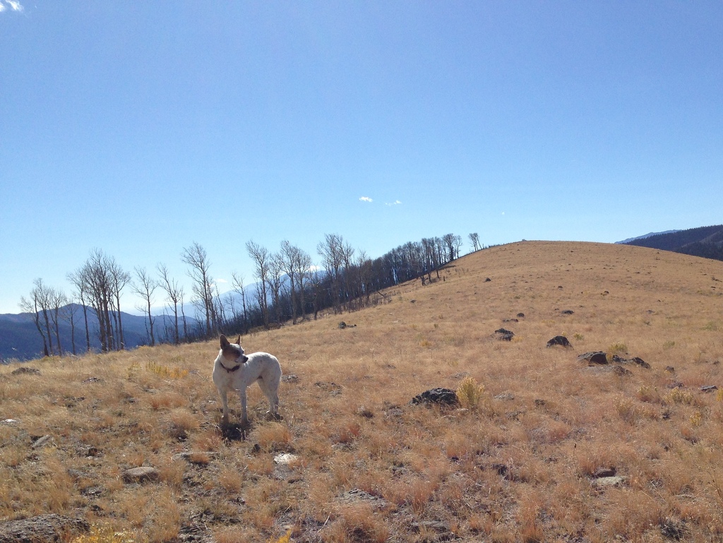 Vicki on Loco Ridge during a scouting hike the day we brought up the trailer. Kill site was down the slope behind her less than half a mile.
So I start scanning the horizon. Yeah yeah, grass. Trees. Bushes. Wait, what's that?
Unmistakable. The head and ears of an ungulate. Far away. Half a mile or more probably. Looking with naked eyes I couldn't see anything. Even with binocs, too far to tell if there are antlers. Not even entirely sure whether it's deer or elk. My tag was for a buck, antlered deer. My thought was, "oh well, pretty far. I'd have to walk right across the meadow out in the open to get closer. No way I'd get there without spooking it. Can't even tell for sure if it isn't a funny shaped log."
My head was in the old way. I was out here with a tag and a rifle, but come on. I'm not going to actually get close enough to shoot a buck. After probably at least 5 minutes, looking over occasionally to see if he was still there, finally I thought, "I might as well try to get close enough to at least see what it is. What have I got to lose?" So I got up, gathered my junk and started crouch-trotting across the open field.
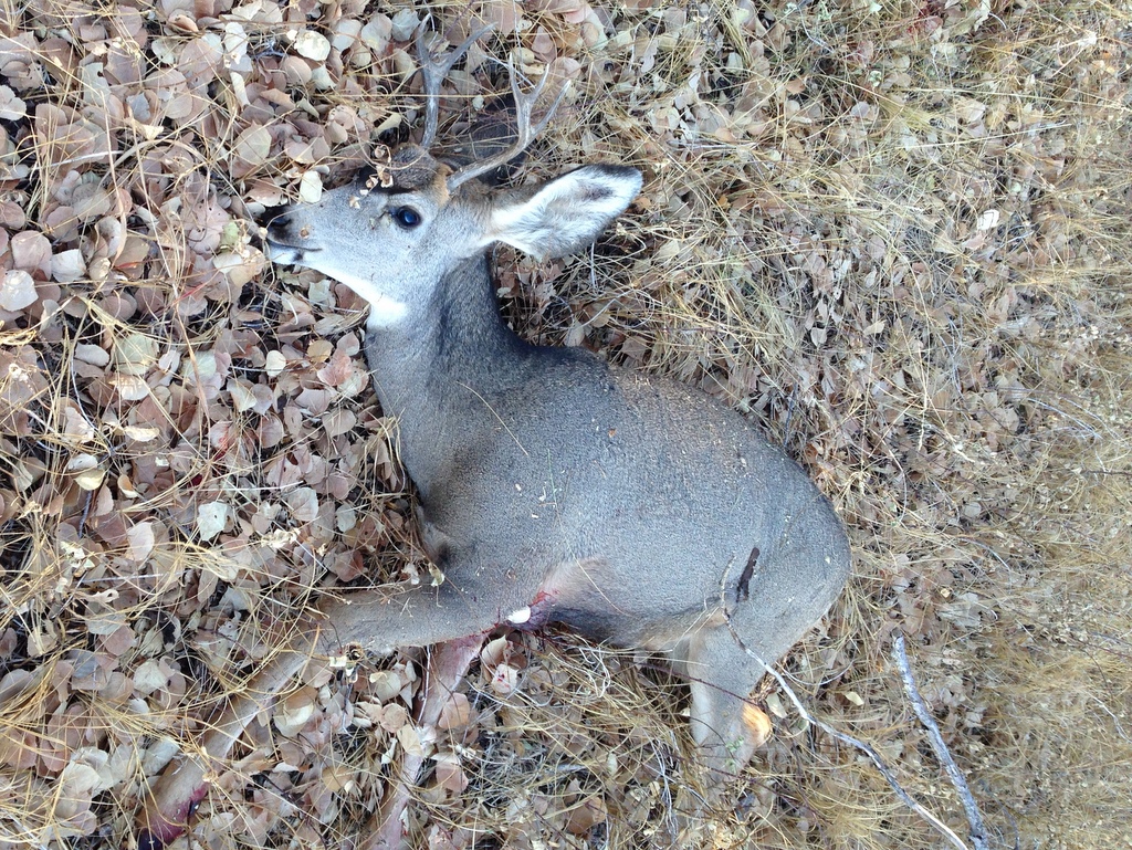
After I'd closed 2 or 3 hundred yards I stopped and kneeled down with my binoculars. Wow. Definitely mule deer. Antlers! Forker. He stood as I was watching. I figured he knew I was there and would run off soon so I crouched a little lower. He was still at least 500 yards away from me, so I wouldn't dream of taking a shot from there. After a couple minutes he was still there, and his back was to me. Maybe he didn't know I was there and had only stood because it was the end of his daytime nap.
I saw a large bush almost between us. If I was uphill 50 yards it would be between us. I quickly moved uphill to put the bush between us, then I ran to it (well, you would probably call it lumbering more than running). I got to the bush and he was still there. I could see antlers well enough to know that he was a 2x3 (two points on one antler, three on the other). Seemed to be 200 yards or less. I don't even remember how I set up the shot, whether I went prone, kneeling; just don't remember. But I did shoot. I had steady crosshairs on an animal standing still sideways to me. Other than being closer, there's not a better situation. So I took the shot.
The deer was hit but didn't go down and started heading away from me into a stand of aspen. I sent a second shot but it was a Hail Mary at a running deer's butt. I really wanted a clean, instant kill. But it was no time to mourn. I had wounded an animal and now there was complete urgency, I needed to put him down. If he kept going I had to track him until I could.
I waited behind the bush for about 30 more seconds after I couldn't see him in the aspen stand he'd gone into. A friend gave me that advice: don't immediately start chasing an animal you've wounded. It might not run for the horizon if you aren't immediately in pursuit. But if you're chasing and it is capable of running, it will run. Wait just a bit then stalk carefully and quietly. Which is what I did.
I crossed the distance I had shot quickly but as quietly as possible toward where he'd been hit. As I reached the edge of the aspen I saw a lot of blood on the grass. It was easy to follow where he went, and after about 100 feet into the aspen I saw him laying in the grass. I felt a little better about my shooting, I'd obviously hit him well enough with one or both shots that he was down. I probably wouldn't be tracking him until it was too dark to see without the headlamp I hadn't brought with me.
As I approached, he moved. Still breathing. Damn. Probably too wounded to get up, but not yet dead. I stopped. Remembering that I'd never extracted the spent round in the chamber I cycled the bolt and loaded a live round from the magazine. He could possibly leap to his feet and run. As I slowly moved closer I could see a jagged exit wound on his chest, I doubted that he would jump up. But he was going to need to be shot again right away.
Emotion was strong in me, as well as adrenaline. I remember as a kid shooting a bird with my BB gun just to kill it, not because I wanted to eat it. As I watched that little bird die on the ground I felt like a terrible, selfish person for just choosing to end this animal's life because I could. That feeling came back to me--a sense of being selfish and cruel. It surprised me, because I'm very comfortable with my reason for hunting. I want the meat. But here I was, an irresponsible little boy holding a rifle above a wounded animal. Then I remembered, I'm harvesting a resource. It's only irresponsible if I waste the resource.
He was beautiful, with healthy coat and looking well-fed. We faced each other, I looked into his eyes and said "thank you", then shot him in the neck from 10 feet away. His rib cage deflated like a un-knotted balloon. The light left his eyes.
 A beautiful, healthy creature whose life I took for my own needs. Grateful for his life. Every bit of meat will be cherished.
I cleared the ammunition out of my rifle chamber and magazine and leaned it against an aspen. It was time to get to work. As I left the trailer to hunt that afternoon, I had grabbed a knife
as an afterthought. Honestly, when I left for the hunt I was pretty sure I'd be back drinking beer pretty soon. Another lesson, don't go out with your rifle unless you have everything else you might need.
I had grabbed the one knife I have with a gut hook, which is fortunate. A gut hook is a curved back tab that's sharp on the inside. It helps to slice open an animal's belly without cutting into the guts.
You want the whole GI tract to come out intact. It's full of bacteria, and that bacteria can help spoil your meat. I knew this. Luckily my bullet hadn't gone through the belly. That happens. It is awful for the animal, and also makes a mess which is a threat to the meat. Gut shot animals often run far before dying slowly in severe pain. It is so very important to place shots carefully.
My first shot was placed very well side to side, but it was 3 or 4 inches below the heart. There was a jagged hole in his lower ribcage where the bullet exited. It could be that I was further than 200 yards, and the bullet had started the drop in trajectory and I hadn't accommodated it by aiming up a little higher. But that would only be an inch or maybe 1.5 at that distance. And I really don't think it was more than 200 yards. As I think about it, a more likely explanation was that I was above him enough that my bullet was slanting downward. It may have entered at the right place, but was heading in the wrong direction and went under the heart. Perhaps I had a little flinch and shot low. Or it was placed wrong and I should have aimed little higher. One of my several regrets about that day is that I did not think to do the forensics, specifically locating the entrance wound so I could know more about how he was shot and why I missed the heart. I'm pretty sure elevation is the answer, but if I'd checked the entrance wound location I would know for sure. Just wasn't present enough.
The bullet took out a big chunk of lung, which also means it took out some large blood vessels. I'm guessing he would have died on his own after 5 or 10 minutes. But I'm sad that I lost the chance for a more humane instant kill.
I read an article a while ago where the author was talking about how primitive even a modern hunting rifle truly is as a tool for killing animals. A small pellet of metal is spit out of a tube from hundreds of yards away by a human being who probably has a high heart rate and shaky hands. The pellet must find vitals and dispatch the animal reliably. Sometimes it works perfectly, sometimes OK, sometimes it's a disaster. Sometimes the bullet just takes out a leg. A deer can still outrun a man using only three legs. I heard a story yesterday about how a young hunter destroyed a deer's lower jaw and the wounded animal wasn't found. That animal could run as fast as a healthy one, and probably lived for weeks before starving or being killed by a predator. To me, causing something like that would be a nightmare.
So obviously shooting well is extremely important to hunt ethically. To shoot well means being able to reliably place the bullet where you want. It takes practice, and you can learn how to shoot well at a rifle range. In my case, I think I shoot reasonably well but I don't fool myself into thinking I'm a great marksman. I have a distance limit. In order to be accurate within inches out further than 100 yards, the rifle needs to be held perfectly still. The tiniest little shake will make the bullet hit feet not inches from the target. Even on the range, I'm hard pressed to reliably perform acceptable shots much past 200 yards.
Another issue that's critical to shooting well especially at long distance is to know your rifle's ballistics/trajectory. My rifle, a .308, is pretty flat out to about 250 yards, but past that the bullet starts to fall fairly quickly. Beyond 250, you better have a range-finder and remember exactly what the drop will be at the accurately-measured distance.
Of course you can also shoot badly in shorter range, which typically comes from not practicing, and/or failing to adjust your scope to confirm that the rifle is even aiming at what the scope is aimed at. And practice will hopefully show you what your limits are, as it has for me. Bad shooting causes gut shots, broken legs, etc. In my opinion, it's unacceptable. Take the shooting seriously or do not hunt.
You need to know how to put the little pellet of metal where you want it, but you also need to know
where that should be. And that means not just putting it behind he shoulder. It means that you need to figure out where is the heart. You need to aim at the heart, where it is in 3D space. If I'd been on flat ground I think I would have been aiming at the heart. But I was far enough above him that I was actually aiming low because of the slant. Next time, if there is a next time, I'll have a lot more knowledge.
Gutting a 250 pound animal is gory. Now might be a time to skip down a few paragraphs if you aren't into specifics.
The method I've been taught is that you use the gut hook to open up the belly while you keep the animal rolled onto its back. Then you tip the animal down so the stuff can fall out. Well, it doesn't just fall out. Your hands are up inside this warm animal, you're cutting and pulling. Massive amounts of blood. Guts you've seen pictures of are right there in your hands, warm and slimy with fresh warm blood. You have your hands way up in there, one holding a sharp knife. Every once in a while a muscle twitches to remind you that this creature was alive minutes ago.
At a point early in the process I dropped the knife and staggered back a couple steps then got down on hands and knees to breath. Overwhelmed. I was a little light-headed, more like faint than puke. It all was so intense. Still had adrenaline from stalking and killing. I didn't need much time to get over it. I caught my breath and in less than a minute and went back to work.
I got as much out of the deer as I could, but I needed a saw to cut the ribcage and pelvis.
Think about that for a second if you aren't familiar with butchering. You need to cut a LOT of bone. You are sawing away on bone that is bleeding; meat and tendons and skin and hair are clogging up the saw teeth. This is intimate. You have ended this creature's life, and now begun the process of dismantling him. It's not pretty. Unless you have a macabre sense of what's pretty.
It was time to go get the truck. But first I needed to drag him out to the jeep road.
The jeep track I'd driven down for the morning hunt was about a quarter mile downhill from the kill site. It was slightly closer to the north, but flat or climbing to get there. Immediately it became obvious that just dragging this guy, even with 30+ pounds of his guts out of him was
work. I had my rifle and binoculars flopping around on me as I yanked at his antler, steering him around rocks and brush. Downhill was hard enough so I didn't bother to take the closest path to the road. Thankfully the kill site wasn't truly rugged ground and it was so close to where I could get my truck. It was hard work, but probably less than 10 minutes. If it had been miles to move him I would have had to go get the saw and frame pack and cut him into multiple parts to carry. And that would have been happening in the dark.
I left him laying in the grass next to the road with my tag attached to an antler. I might have done the tagging later since I only had a little more daylight left, but if a game warden found him before I could get back it would be technically poaching without the tag attached. Ten minutes walking back to camp, start truck, probably ten minutes to creep down the jeep road to where my deer lay.
Loading this guy into my truck almost killed me. I couldn't lift him. Luckily I had a come-along with me, which is a winch tool. But even with that it was an awkward grunt. I had some lumber with me, but only 4 foot 2x4s. A 6+ foot long 2x8 would have helped but I had nothing like that. The 2x4s helped, but barely. It was awkward. With one other person, even if that person was a 12 year old, it would have been easy. By myself it was a bitch. But it had to be done and nobody was there to help.
When I got back to camp I noticed that it was 5:10. Wow. Only like 90 minutes since I'd left to go on the hunt. Seemed like it had been hours. But that just meant I wouldn't have to hang him, finish gutting, and skin him completely in the darkness. Found a tree to hang him from and for almost three hours I was working on dressing out his carcass. As I worked, he looked less and less like a deer and more like a carcass.
As I worked on this animal with knives and saws I was surprised by how well I adjusted to it. I've known people who hunted until the day they killed something and had to field dress it. Some people can't do it and I'm telling you, I get that. Field dress a deer and there's nothing abstract about the life that's been taken. It's as real as the blood and hair and shit all over your hands and clothes as you dismantle it.
Very hard work, and dangerous. I cut myself three or four times, luckily only minor. But you really have to be careful, because often you are in there pulling with your left hand and cutting with your right. After I cut my left thumb at around 7:30 I made myself stop and think. If I cut myself BAD it will be an hour of 4-wheeling just to get to town for stitches. If it was REALLY BAD I might have to use my SPOT beacon to call in Search and Rescue. Be careful dipshit!
I was struggling with the animal's rear end. The way the pelvis holds the poop chute plumbing is hard to deal with. I remember that there's a clean method for doing it which I tried from my memory but couldn't get to work. I'll need to find that youtube and review it before elk season starts. But I didn't have youtube and I was struggling.
The deer's bladder was hanging out of the gore, and it was pretty full. My tired and addled brain said, "Wish he'd peed before I shot him. I don't want that pee all over the carcass, maybe I should drain it before cutting it out so I can control where the pee goes." So I poked it with the tip of my skinning knife and it immediately flopped over to aim right at my chest. Argh! Really controlled where it went. 90% of it wound up all over me.
At least I didn't get much pee on the carcass! For just a second I was angry (might say
pissed off), but then I just kind of chuckled at my goofiness and got on with it.
Skinning was the easy part. Glad I did it while he was still warm, it's harder once the animal has gotten cold. I skinned him down to where the skin was all hanging over his head inside out (he was hung by the rear legs) and then called it a night. I was super tired and there was beer to drink. And really, the next thing that needed to happen to the carcass for the sake of the meat was to chill down. It had been dark for a couple hours and was starting to cool down, but only the 50s. A nice night in the 20s would really make Sunday easier because I wouldn't have to hurry so much to find him a cooler. But 39 was the low, which was adequate. We've been having a fair (but windy) October. Even at 9500 feet where my camp was it just wasn't very cold for the time of year.
In the morning I cut away the now very leathery skin and then used a saw to cut off his head. Then I backed the truck over to where I could just swing him onto the tailgate rather than drop him to the ground and have to lift him. I laid a blue tarp in the truck and slid him in. The skin, head, complete guts had to be close to a 1/3 of his weight. So much easier to load. I could have dead-lifted him if needed. He was loaded up. I gathered meat scraps, organs, etc that had been scattered around, and took them and the skin a couple hundred yards from camp. Most of it other than the hide are probably gone already. Lots of smaller critters will benefit from the parts I did not take. If there's a next time I'll keep some of the organ meat.
I also filled a construction garbage bag with glass, cans, and various junk that previous campers had left around the camp site. I always feel good about using public land when I'm able to leave it better than it was.
I hooked up the trailer and got everything ready and by probably 7:15 I was on my way back down to town. As I was approaching the top of the first steep rubble filled section of jeep road I stopped to shift my transfer case into low range. It dawned on me that I should try to post to Facebook for help finding a cooler to store him until it was time to process. Fortunately my phone had data service, so I sat there in my idling truck in neutral typing a post to Facebook asking if anyone knew of a cooler in town where I could rent space. Sunday morning! I wasn't going to find many businesses answering phones. It would certainly get up into the 70s in town, no way I could wait until Monday. So I sent the post and then went to work getting my truck and trailer safely out.
Getting to town took time. I can get there or back in the truck without the trailer in under an hour, but it took close to 90 minutes to get down with the trailer. Lots of 1.5 mph engine braking and bumping and lurching.
Thanks to the closeness of the community, I found a cooler within a couple hours of getting home. Met the guy who had the cooler and dropped off the carcass. Then I went home and sawed a cap of his skull that had the antlers growning out. Then put the head without antlers into a plastic bag and into my freezer. The enormous ears (there's a reason they're called mule deer) had to be folded down to get the door to close.
Then it was time to clean knives and saws. Unload the trailer and sort out all the gear. Before I knew it 4 PM had arrived, I'd never eaten lunch (had an energy bar for breakfast), and I was shelled. I didn't do anything else the rest of the day.
Monday I took his head to the Division of Wildlife and dropped it off for CWD (Chronic Wasting Disease) testing. CWD is related to BSE (Bovine spongiform encephalopathy), aka Mad Cow Disease. This is most often found in Colorado deer populations east and north of us, but it's been found elsewhere. I will not eat any of the meat until I get a negative test result.
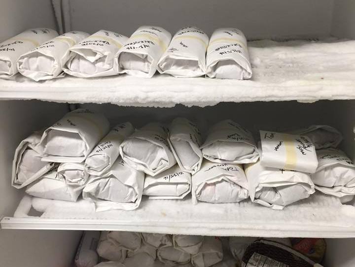 The end goal of the whole process, meat ready to cook and eat.
Tuesday afternoon I get 100 lbs of ice, picked up the carcass and packed it in ice in my truck bed then drove to Buena Vista were my friend Wes had offered to process/butcher the carcass for me for a reasonable fee. More importantly she'd let me watch and learn.
Wow, there's way more to processing than I had expected. Wes is a chef, and she focused on and prepared each piece of meat. Even the stew meat and grinding meat got focused trimming and examination. And of course she knows which cuts are better meat and which should be used for soup or sausage. While she was working she frequently commented about how nice the meat was. It was a healthy, well-fed animal, and I handled it well. I'm proud of that. I honored his life by focusing on the care of the meat and making sure I got a good harvest.
I can see the value of having the meat professionally processed now. I would have hacked it up and packed it away not knowing much about what to write on each package. But processing is not free, even if you have a friend who will do it for a reasonable fee.
So this meat was not cheap. I spent weeks scouting. I probably used up two tanks of gas getting up into the hills for scouting and hunting. And there was lots of 4-wheeling which is hard on tires and pretty much everything else on the truck. Cost me $20 to store for three days in a cooler. About $25 just for ice to transport him. I'll be handing Wes some cash, I won't say how much in case she wants to charge someone else who reads this a different amount. She deserves it for hours of effort. It was money well spent but still money. Burned a couple $30 boxes of ammo sighting in my rifle. Time, effort, whatever part of a $750 rifle and $100 worth of knives and saw I assign this animal (depreciation?).
You do this because you enjoy the process and because you
prefer game meat to domestic meat. And in my case, I felt that it was an important experience to have as a meat-eater. Buying meat that someone else has killed and butchered is handy, but I needed to know I could handle doing it myself when needed.
So all I have to do is drive up there to collect my meat and pay Wes, then put it in my freezer. Once it's there and I get back the results of the CWD test, this chapter will be over. But then next week I'll be dragging my trailer up into a different game unit and getting ready to hunt elk starting 11-5-2016.
I'm humbled by the prospect of killing an elk. I don't think I'm going to hunt as far from the road as I have traditionally. I'd like to be inside of 90 minutes for haul trips. A strenuous 4 hour haul trip would make for days of retrieval. And if it isn't cold enough during the day, some of the meat waiting to be hauled out could spoil. I have some friends who've offered to come up and help me haul, and I may need to take them up on it. But I can't ask them to do 4+ hour round trips. And even with help there could be meat out there for too long.
I've learned much from this experience; about hunting and myself. I'm moving forward as a hunter, hopefully a little wiser. And now I'll have at least the 70-100 lbs of meat that came off this buck for the winter. As of now, I intend to buy no meat until all my venison is gone.That's the rest of the way I'm going to honor the life that I took.